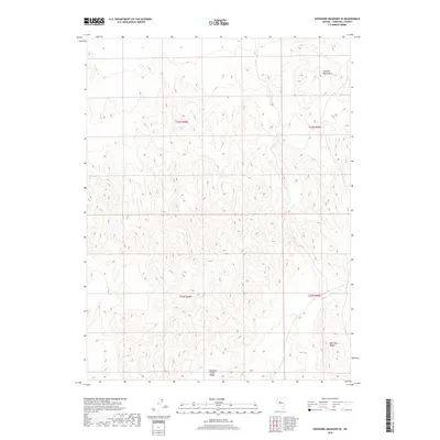
2018 Map of Shoshone Meadows SE
USGS Topo · Published 2018About this map
Edwards Creek Valley dominates the southern reaches of this landscape, marking a clear topographic transition where the high desert floor meets rising peaks. To the northeast, the Augusta Mountains define the high ground, while the southeastern corner is anchored by the New Pass Range. This 2018 survey reveals a terrain defined strictly by natural relief and public land divisions, including townships t23n r39e and t23n r40e, without the footprint of modern settlement or infrastructure. The concentration of contour lines across the Augusta Mountains illustrates the significant elevation changes that isolate this part of Churchill County from more developed regions of the state.
Find a feature on this map
7 named features on this map. Tap any name to fly to it.
Don’t see what you’re looking for? This feature index may not catch every label — zoom into the map to look around manually.
Map Details
Editions of this 2018 Shoshone Meadows SE Map
This is the sole edition of this map. No revisions or reprints were ever made.
Other maps of this area

1955 · Millett
USGS Topo · 1:250,000

1959 · Millett
USGS Topo · 1:250,000

1966 · Shoshone Meadows
USGS Topo · 1:62,500

1966 · Edwards Creek Valley
USGS Topo · 1:62,500

1969 · Gilbert Creek SW
USGS Topo · 1:24,000
1969 · Gilbert Creek NW
USGS Topo · 1:24,000

1969 · Mount Airy NW
USGS Topo · 1:24,000

1983 · Edwards Creek Valley
USGS Topo · 1:100,000
1990 · Hole In The Wall
USGS Topo · 1:24,000
1990 · Shoshone Meadows
USGS Topo · 1:24,000