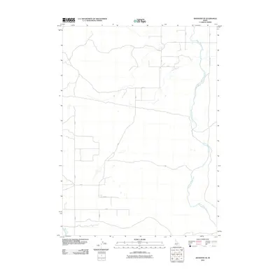
2010 Map of Shoshone SE
USGS Topo · Published 2010About this map
Milner Gooding Canal snakes through the eastern section of this landscape, serving as a primary artery for the irrigation infrastructure that defines agriculture in southern Idaho. The map reveals a strictly orthogonal grid of rural roads, including S 450 E and E 870 S, which carve the high desert into manageable tracts. The North Side Main Canal clips the southwestern corner, further emphasizing the engineered nature of the water supply in this region. This 2010 survey by the U.S. Geological Survey documents the persistence of large-scale ranching and farming divisions, where long stretches of road like Dietrich Butte Rd and N 800 E connect isolated homesteads to the wider transport network. The sparse label set reflects a quiet, functional landscape dominated by gravity-fed water systems and straight-line boundaries.
Find a feature on this map
15 named features on this map. Tap any name to fly to it.
Don’t see what you’re looking for? This feature index may not catch every label — zoom into the map to look around manually.
Map Details
Editions of this 2010 Shoshone SE Map
This is the sole edition of this map. No revisions or reprints were ever made.
Other maps of this area

1955 · Twin Falls
USGS Topo · 1:250,000

1958 · Twin Falls
USGS Topo · 1:250,000

1964 · Falls City
USGS Topo · 1:24,000

1964 · Perrine
USGS Topo · 1:24,000

1964 · Hunt
USGS Topo · 1:24,000

1971 · Shoshone SE
USGS Topo · 1:24,000

1971 · Star Lake
USGS Topo · 1:24,000

1971 · Dietrich
USGS Topo · 1:24,000
1971 · Shoshone SW
USGS Topo · 1:24,000

1971 · Dietrich Butte
USGS Topo · 1:24,000