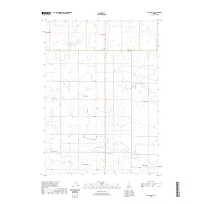
2020 Map of Shoshone SW
USGS Topo · Published 2020About this map
The North Side Main Canal and an intricate network of irrigation laterals dominate this agricultural landscape along the border of Jerome and Lincoln counties. This 2020 survey illustrates the sophisticated water management systems essential to the region, featuring major arteries like the R Canal and P Canal alongside smaller distribution channels such as Pd-4 Ditch. The terrain is partitioned by a rigid grid of rural roads, including Three Mile Wendell Rd and Hall Rd, which facilitate access to the surrounding farmsteads. The transition from the northern Lincoln County line into the southern reaches of Jerome County is marked by a shift in lateral configurations, with features like Lateral Pe-1 and Lateral R-14 carving through the township sections. This map serves as a contemporary record of Idaho's engineered agricultural heritage, showing how water is methodically diverted from the main canals into various named laterals to sustain the high desert plains.
Find a feature on this map
53 named features on this map. Tap any name to fly to it.
Don’t see what you’re looking for? This feature index may not catch every label — zoom into the map to look around manually.
Map Details
Editions of this 2020 Shoshone SW Map
This is the sole edition of this map. No revisions or reprints were ever made.
Other maps of this area

1950 · Jerome
USGS Topo · 1:24,000

1950 · Jerome
USGS Topo · 1:62,500

1955 · Twin Falls
USGS Topo · 1:250,000

1958 · Twin Falls
USGS Topo · 1:250,000

1964 · Falls City
USGS Topo · 1:24,000

1964 · Perrine
USGS Topo · 1:24,000

1971 · Shoshone SE
USGS Topo · 1:24,000

1971 · Dietrich
USGS Topo · 1:24,000

1971 · Tunupa
USGS Topo · 1:24,000
1971 · Gooding SE
USGS Topo · 1:24,000