
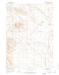
1950 Map of Shotgun Butte
USGS Topo · Published 1952About this map
The Wind River Indian Reservation landscape is defined by the winding course of Muddy Creek and the prominent landmark of Shotgun Butte. This 1950s study, conducted for the development of the Missouri River Basin, reveals a remote ranching territory at a time when water management was reshaping the High Plains. The Riverton Reclamation Project (Withdrawal Area) covers the southeastern corner, signaling a period of federal land-use transition. Scattered family-named ranching operations, such as Arapahoe Ranch and Merriam Ranch, are connected by an intricate network of waterways including Deer Creek and Shotgun Creek. The mention of the Shotgun Ranch (Aban'd) provides a specific waypoint for local historians tracking the cycle of settlement and departure in this arid Wyoming environment.
Find a feature on this map
17 named features on this map. Tap any name to fly to it.
Don’t see what you’re looking for? This feature index may not catch every label — zoom into the map to look around manually.
Map Details
Editions of this 1950 Shotgun Butte Map
2 editions found
Other maps of this area

1950 · Pavillion Butte
USGS Topo · 1:24,000

1950 · Harris Bridge
USGS Topo · 1:24,000

1951 · Eagle Point
USGS Topo · 1:24,000

1951 · Lookout Butte
USGS Topo · 1:24,000

1951 · Jenkins Mountain
USGS Topo · 1:24,000

1952 · Kates Basin
USGS Topo · 1:24,000

1952 · Sheep Ridge
USGS Topo · 1:24,000

1952 · Bargee
USGS Topo · 1:24,000

1955 · Thermopolis
USGS Topo · 1:250,000
1957 · Jenkins Mountain
USGS Topo · 1:24,000