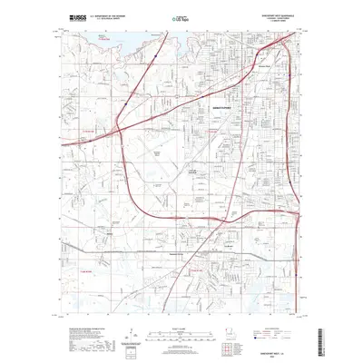
2020 Map of Shreveport West
USGS Topo · Published 2020About this map
Shreveport expands westward into the drainage basins of Gilmer Bayou and Brush Bayou in this recent survey. The landscape is defined by the significant footprint of the Shreveport Regional Airport and the heavy industrial corridors along the Bert Kouns Industrial Loop. For those researching family history, the map provides a comprehensive look at the area's numerous cemeteries and religious sites, ranging from the Hebrew Rest Cem and Saint Joseph Cem in the north to the Mount Zion Baptist Church Cem in the south. The transition from the urban density of Werner Park to the developing suburbs of Summer Grove and Reisor is clearly marked by the dense network of local streets that intersect major thoroughfares like Mansfield Rd and Greenwood Rd.
Find a feature on this map
46 named features on this map. Tap any name to fly to it.
Don’t see what you’re looking for? This feature index may not catch every label — zoom into the map to look around manually.
Map Details
Editions of this 2020 Shreveport West Map
This is the sole edition of this map. No revisions or reprints were ever made.
Other maps of this area

1932 · Bossier SW
USGS Topo · 1:31,680

1932 · Shreveport SE
USGS Topo · 1:31,680

1941 · Forbing
USGS Topo · 1:31,680

1945 · Greenwood
USGS Topo · 1:62,500

1948 · Mooringsport
USGS Topo · 1:62,500

1948 · Bossier City
USGS Topo · 1:62,500

1948 · Caspiana
USGS Topo · 1:62,500

1955 · Shreveport
USGS Topo · 1:250,000
1955 · Bossier City
USGS Topo · 1:24,000

1955 · Shreveport East
USGS Topo · 1:24,000