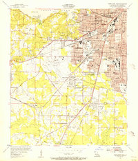
1955 Map of Shreveport West
USGS Topo · Published 1956About this map
The State Fairground and Greater Shreveport Airport anchor this mid-century view of Louisiana's growing western flank. The urban grid of Shreveport pushes toward the west and south, where developing neighborhoods like Caddo Heights and Hollywood meet older landmarks such as The Pines Sanatorium and Coleman College. The industrial and logistics infrastructure of the era is clearly defined by several Tank Farm sites and the convergence of the Texas and Pacific, Illinois Central, and Kansas City Southern railroads.
Find a feature on this map
78 named features on this map. Tap any name to fly to it.
Don’t see what you’re looking for? This feature index may not catch every label — zoom into the map to look around manually.
Map Details
Editions of this 1955 Shreveport West Map
This is the sole edition of this map. No revisions or reprints were ever made.
Other maps of this area

1932 · Bossier SW
USGS Topo · 1:31,680

1932 · Shreveport SE
USGS Topo · 1:31,680

1941 · Forbing
USGS Topo · 1:31,680

1945 · Greenwood
USGS Topo · 1:62,500

1948 · Mooringsport
USGS Topo · 1:62,500

1948 · Bossier City
USGS Topo · 1:62,500

1948 · Caspiana
USGS Topo · 1:62,500

1955 · Shreveport
USGS Topo · 1:250,000
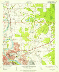
1955 · Bossier City
USGS Topo · 1:24,000

1955 · Shreveport East
USGS Topo · 1:24,000