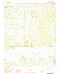
1983 Map of Shuford
USGS Topo · Published 1983About this map
Enid Lake dominates the southern landscape of this 1980s survey, marking a significant hydrological shift at the border of Panola and Yalobusha counties. The northern portion of the quadrangle retains a traditional rural character, centered around small communities like Shuford and Eureka Springs. This area is defined by a network of drainage systems, including Long Creek, Kenny Creek, and Caney Creek, which flow through the dissected uplands toward the reservoir.
Find a feature on this map
31 named features on this map. Tap any name to fly to it.
Don’t see what you’re looking for? This feature index may not catch every label — zoom into the map to look around manually.
Map Details
Editions of this 1983 Shuford Map
This is the sole edition of this map. No revisions or reprints were ever made.
Other maps of this area

1940 · Oxford
USGS Topo · 1:62,500

1943 · Oxford
USGS Topo · 1:62,500

1952 · Sardis
USGS Topo · 1:62,500

1953 · Sardis
USGS Topo · 1:62,500

1954 · Oakland
USGS Topo · 1:62,500

1954 · Water Valley
USGS Topo · 1:62,500

1954 · Water Valley West
USGS Topo · 1:24,000

1955 · Water Valley
USGS Topo · 1:62,500

1956 · Tupelo
USGS Topo · 1:250,000

1958 · Tupelo
USGS Topo · 1:250,000