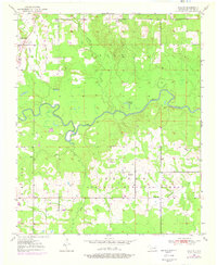
1950 Map of Shults
USGS Topo · Published 1976About this map
The Little River meanders across the center of this Oklahoma landscape, defining the transition between the townships of Eagle and Frisco. The rural character of McCurtain County is evident in the cluster of community landmarks such as Redland, which is anchored by the Redland Cem, and the small settlement at Shults. These locales, along with Welch Store, represent the dispersed commercial and social nodes typical of the region before more modern consolidation.
Find a feature on this map
22 named features on this map. Tap any name to fly to it.
Don’t see what you’re looking for? This feature index may not catch every label — zoom into the map to look around manually.
Map Details
Editions of this 1950 Shults Map
2 editions found
Other maps of this area

1902 · Lukfata
USGS Topo · 1:125,000

1950 · Mcalester
USGS Topo · 1:250,000

1950 · Idabel
USGS Topo · 1:24,000

1950 · Shults
USGS Topo · 1:24,000

1950 · Haworth
USGS Topo · 1:24,000

1950 · Goodwater
USGS Topo · 1:24,000

1950 · Bokhoma
USGS Topo · 1:24,000

1951 · Idabel
USGS Topo · 1:24,000

1951 · Idabel SE
USGS Topo · 1:24,000

1951 · Haworth
USGS Topo · 1:24,000