
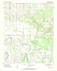
1951 Map of Idabel SE
USGS Topo · Published 1951About this map
The Red River creates a dynamic southern boundary for McCurtain County on this 1951 survey, where the river's shifting path is marked by numerous oxbows and secondary water bodies. Landmarks like Bryarly Cut-off and the Eagle Bend Cut-off illustrate the evolving hydrology of the border between Oklahoma and Texas. To the north, the St Louis San Francisco railroad cuts through the landscape, supporting a network of rural communities defined by their social centers.
Find a feature on this map
35 named features on this map. Tap any name to fly to it.
Don’t see what you’re looking for? This feature index may not catch every label — zoom into the map to look around manually.
Map Details
Editions of this 1951 Idabel SE Map
2 editions found
Other maps of this area

1950 · Idabel
USGS Topo · 1:24,000

1950 · Acworth
USGS Topo · 1:24,000

1950 · De Kalb NW
USGS Topo · 1:24,000

1950 · White Rock
USGS Topo · 1:24,000

1950 · Shults
USGS Topo · 1:24,000

1950 · Haworth
USGS Topo · 1:24,000

1951 · Idabel
USGS Topo · 1:24,000

1951 · Garvin
USGS Topo · 1:24,000

1951 · English
USGS Topo · 1:24,000

1951 · White Rock
USGS Topo · 1:24,000