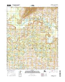
2016 Map of Shungnak A-3 SE
USGS Topo · Published 2016About this map
Billy Hawk Creek meanders through the northwest and northeast sections of this remote Alaskan interior landscape, defining much of the drainage pattern in the northern half of the quadrangle. The terrain is characterized by an intricate network of wetlands and small water bodies, typical of the subarctic environment in the Yukon-Koyukuk region. In the northern reaches, the elevation rises sharply from the surrounding flats, with contours reaching several hundred feet to form a prominent topographic barrier above the lower Billy Hawk Creek basin. The map illustrates a vast, uninhabited wilderness structured by the Public Land Survey System, showing the junctions of Township 8 North, Range 8 East and Township 7 North, Range 9 East. The absence of roads or permanent settlements underscores the isolation of this interior territory during the mid-2010s.
Find a feature on this map
6 named features on this map. Tap any name to fly to it.
Don’t see what you’re looking for? This feature index may not catch every label — zoom into the map to look around manually.
Map Details
Editions of this 2016 Shungnak A-3 SE Map
This is the sole edition of this map. No revisions or reprints were ever made.
Other maps of this area

1951 · Shungnak
USGS Topo · 1:250,000

1951 · Kateel River
USGS Topo · 1:250,000

1954 · Kateel River D-3
USGS Topo · 1:63,360

1955 · Shungnak
USGS Topo · 1:250,000

1955 · Kateel River D-2
USGS Topo · 1:63,360

1955 · Kateel River
USGS Topo · 1:250,000

1964 · Shungnak
USGS Topo · 1:250,000
1985 · Shungnak A-3
USGS Topo · 1:63,360
1985 · Shungnak A-2
USGS Topo · 1:63,360
2016 · Kateel River D-3 NW
USGS Topo · 1:25,000