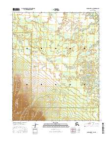
2016 Map of Shungnak B-1 NE
USGS Topo · Published 2016About this map
Pah River Flats dominates this remote Arctic interior landscape, where the meandering Pah River cuts through the marshy lowland before reaching the southern hills. The map depicts a critical administrative boundary line where the Northwest Arctic Borough Yukon-Koyukuk Census Area separates two vast Alaskan jurisdictions. This 2016 survey illustrates the stark topographical transition from the saturated river basin to the rising elevations of the southern townships, including t11n r12e and t11n r13e, providing a precise record of watercourses and elevation contours in a roadless wilderness area of the Brooks Range foothills.
Find a feature on this map
9 named features on this map. Tap any name to fly to it.
Don’t see what you’re looking for? This feature index may not catch every label — zoom into the map to look around manually.
Map Details
Editions of this 2016 Shungnak B-1 NE Map
This is the sole edition of this map. No revisions or reprints were ever made.
Other maps of this area

1951 · Shungnak
USGS Topo · 1:250,000

1951 · Hughes
USGS Topo · 1:250,000

1955 · Shungnak
USGS Topo · 1:250,000

1956 · Hughes
USGS Topo · 1:250,000

1964 · Shungnak
USGS Topo · 1:250,000

1964 · Hughes
USGS Topo · 1:250,000

1965 · Hughes
USGS Topo · 1:250,000
1985 · Shungnak B-1
USGS Topo · 1:63,360
1985 · Shungnak C-1
USGS Topo · 1:63,360
1986 · Hughes B-6
USGS Topo · 1:63,360