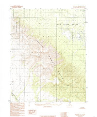
1985 Map of Shungnak B-1
USGS Topo · Published 1985About this map
Zane Hills dominate the center of this 1985 survey, marking a rugged high-ground transition where the Continental Divide winds through the interior Alaskan landscape. To the north, the terrain drops into the extensive wetlands of the Pah River Flats, a stark contrast to the sharp elevations of the hills themselves. The western edge of the map identifies a portion of the Selawik National Wildlife Refuge, indicating the protected status of these remote drainage basins. Down in the southwestern corner, Wheeler Creek cuts through the topography, serving as a primary watercourse for the area. This map reflects a landscape defined entirely by its natural hydrology and geography, with the Zane Pass providing a named navigational point through the northern ridges. The absence of roads or permanent settlements emphasizes the wilderness character of the Yukon-Koyukuk region during the late twentieth century.
Find a feature on this map
8 named features on this map. Tap any name to fly to it.
Don’t see what you’re looking for? This feature index may not catch every label — zoom into the map to look around manually.
Map Details
Editions of this 1985 Shungnak B-1 Map
This is the sole edition of this map. No revisions or reprints were ever made.
Other maps of this area

1951 · Shungnak
USGS Topo · 1:250,000

1951 · Hughes
USGS Topo · 1:250,000

1955 · Shungnak
USGS Topo · 1:250,000

1956 · Hughes
USGS Topo · 1:250,000

1964 · Shungnak
USGS Topo · 1:250,000

1964 · Hughes
USGS Topo · 1:250,000

1965 · Hughes
USGS Topo · 1:250,000
1985 · Shungnak A-1
USGS Topo · 1:63,360
1985 · Shungnak C-1
USGS Topo · 1:63,360
1985 · Shungnak B-2
USGS Topo · 1:63,360