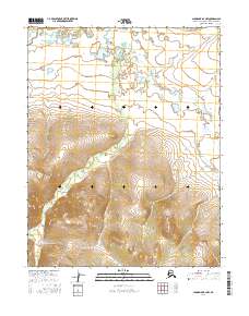
2016 Map of Shungnak B-2 NW
USGS Topo · Published 2016About this map
Selawik River meanders through the northern expanse of this Northwest Arctic landscape, forming a complex network of wetlands and oxbow lakes. The terrain transitions from these low-lying fluvial plains into significant upland elevations to the south, where the drainage of Shiniliaok Cr carves through the rising topography. This 2016 survey illustrates the stark contrast between the riparian corridors and the high ridges that define the inland geography of the Shungnak B-2 NW quadrangle. The lack of established infrastructure or settlements emphasizes the remote nature of the region, where the natural water systems remain the primary geographic landmarks across the vast sections of t13n r9e and t12n r9e.
Find a feature on this map
8 named features on this map. Tap any name to fly to it.
Don’t see what you’re looking for? This feature index may not catch every label — zoom into the map to look around manually.
Map Details
Editions of this 2016 Shungnak B-2 NW Map
This is the sole edition of this map. No revisions or reprints were ever made.
Other maps of this area

1951 · Shungnak
USGS Topo · 1:250,000

1955 · Shungnak
USGS Topo · 1:250,000

1964 · Shungnak
USGS Topo · 1:250,000
1985 · Shungnak B-3
USGS Topo · 1:63,360
1985 · Shungnak C-3
USGS Topo · 1:63,360
1985 · Shungnak B-2
USGS Topo · 1:63,360
1985 · Shungnak C-2
USGS Topo · 1:63,360
2016 · Shungnak B-3 SE
USGS Topo · 1:25,000
2016 · Shungnak C-3 SE
USGS Topo · 1:25,000
2016 · Shungnak B-2 SW
USGS Topo · 1:25,000