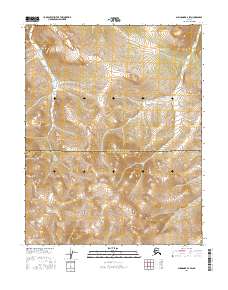
2016 Map of Shungnak B-2 SW
USGS Topo · Published 2016About this map
Purcell Mountains dominate this 2016 survey of the Alaskan interior, where the high-altitude terrain is delineated by sharp contour lines and ridge systems. The map captures the remote boundary between the Northwest Arctic Borough and the Yukon-Koyukuk Census Area, marking a significant administrative divide in the wilderness. Winding through the northeastern section, the Selawik River follows a tight drainage pattern between the peaks, illustrating the headwater geography of this subarctic landscape. The lack of roads or settlements emphasizes the isolation of this region within the Public Land Survey System grids of t11n r9e, t11n r10e, t10n r9e, and t10n r10e.
Find a feature on this map
7 named features on this map. Tap any name to fly to it.
Don’t see what you’re looking for? This feature index may not catch every label — zoom into the map to look around manually.
Map Details
Editions of this 2016 Shungnak B-2 SW Map
This is the sole edition of this map. No revisions or reprints were ever made.
Other maps of this area

1951 · Shungnak
USGS Topo · 1:250,000

1955 · Shungnak
USGS Topo · 1:250,000

1964 · Shungnak
USGS Topo · 1:250,000
1985 · Shungnak A-3
USGS Topo · 1:63,360
1985 · Shungnak B-3
USGS Topo · 1:63,360
1985 · Shungnak B-2
USGS Topo · 1:63,360
1985 · Shungnak A-2
USGS Topo · 1:63,360
2016 · Shungnak B-3 SE
USGS Topo · 1:25,000
2016 · Shungnak A-2 NE
USGS Topo · 1:25,000
2016 · Shungnak A-2 NW
USGS Topo · 1:25,000