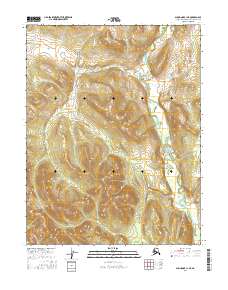
2016 Map of Shungnak C-1 NE
USGS Topo · Published 2016About this map
Pah River winds through this northern landscape, serving as the central geographic feature in a region defined by its complex hydrography and varying elevations. The terrain is marked by a series of north-south ridges and drainages, providing a clear view of the natural corridors used for navigation in the Northwest Arctic borough. This 2016 survey by the U.S. Geological Survey utilizes high-resolution imagery and contour data to delineate the intricate watershed of the Pah River as it passes through several townships. The absence of developed roads or named settlements underscores the character of this area as a preserved natural environment, where the topography itself dictates the movement of water and those traveling through the territory.
Find a feature on this map
7 named features on this map. Tap any name to fly to it.
Don’t see what you’re looking for? This feature index may not catch every label — zoom into the map to look around manually.
Map Details
Editions of this 2016 Shungnak C-1 NE Map
This is the sole edition of this map. No revisions or reprints were ever made.
Other maps of this area

1951 · Shungnak
USGS Topo · 1:250,000

1951 · Hughes
USGS Topo · 1:250,000

1955 · Shungnak
USGS Topo · 1:250,000

1956 · Hughes
USGS Topo · 1:250,000

1964 · Shungnak
USGS Topo · 1:250,000

1964 · Hughes
USGS Topo · 1:250,000

1965 · Hughes
USGS Topo · 1:250,000
1985 · Shungnak D-1
USGS Topo · 1:63,360
1985 · Shungnak C-1
USGS Topo · 1:63,360
1986 · Hughes D-6
USGS Topo · 1:63,360