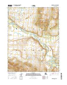
2016 Map of Shungnak D-1 SE
USGS Topo · Published 2016About this map
The Kobuk River dominates this landscape, winding through a remote expanse of the Northwest Arctic. The river's path is characterized by significant shifts in direction and elevation, most notably at the Pah Rapids, where the water meets a more turbulent section of the channel. This 2016 survey illustrates the complex drainage network of the region, where the Killak River and the Pah River contribute to the larger Kobuk system. The terrain transitions from broad river valleys to more pronounced topographic rises, as indicated by the tight contouring in the northeastern and southern quadrants of the quadrangle. The map detail reflects the shifting nature of these subarctic waterways, which remain critical corridors for travel and subsistence in this part of Alaska.
Find a feature on this map
8 named features on this map. Tap any name to fly to it.
Don’t see what you’re looking for? This feature index may not catch every label — zoom into the map to look around manually.
Map Details
Editions of this 2016 Shungnak D-1 SE Map
This is the sole edition of this map. No revisions or reprints were ever made.
Other maps of this area

1951 · Shungnak
USGS Topo · 1:250,000

1951 · Hughes
USGS Topo · 1:250,000

1955 · Shungnak
USGS Topo · 1:250,000

1956 · Hughes
USGS Topo · 1:250,000

1964 · Shungnak
USGS Topo · 1:250,000

1964 · Hughes
USGS Topo · 1:250,000

1965 · Hughes
USGS Topo · 1:250,000
1985 · Shungnak D-1
USGS Topo · 1:63,360
1985 · Shungnak C-1
USGS Topo · 1:63,360
1986 · Hughes D-6
USGS Topo · 1:63,360