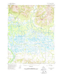
1955 Map of Shungnak D-2
USGS Topo · Published 1967About this map
The Kobuk River meanders across this mid-century landscape, carving a complex network of oxbows and sloughs through the central lowlands. To the north, the terrain rises sharply into the high peaks of the Brooks Range, dominated by the prominent heights of Asbestos Mountain, Inerevuk Mountain, and Ferguson Peak. The settlement of Kobuk sits near the river's bend, serving as a primary point of reference in an area defined by its remote waterways and mineral prospects.
Find a feature on this map
29 named features on this map. Tap any name to fly to it.
Don’t see what you’re looking for? This feature index may not catch every label — zoom into the map to look around manually.
Map Details
Editions of this 1955 Shungnak D-2 Map
3 editions found
Other maps of this area

1951 · Shungnak
USGS Topo · 1:250,000

1951 · Ambler River
USGS Topo · 1:250,000

1955 · Shungnak
USGS Topo · 1:250,000

1955 · Shungnak D-2
USGS Topo · 1:63,360

1955 · Shungnak D-3
USGS Topo · 1:63,360

1956 · Ambler River
USGS Topo · 1:250,000

1964 · Shungnak
USGS Topo · 1:250,000

1964 · Ambler River
USGS Topo · 1:250,000
1985 · Ambler River A-3
USGS Topo · 1:63,360
1985 · Ambler River A-2
USGS Topo · 1:63,360