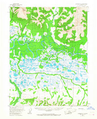
1955 Map of Shungnak D-2
USGS Topo · Published 1967About this map
Asbestos Mountain and Inerevuk Mountain dominate the northern skyline of this Alaskan landscape, where resource extraction and bush aviation define the mid-century wilderness. The drainage network is anchored by the meandering Kobuk River, which receives the waters of the Kogoluktuk River and numerous smaller tributaries like Dahl Creek and California Creek. Evidence of early industrial interest is noted at the Mine near the foot of the mountains, supported by the Dahl Creek Landing Strip. To the south, the terrain flattens into a complex web of wetlands and small lakes between the Kuikcherk River and the Pick River, eventually rising again into the Lockwood Hills. This survey provides a precise record of a remote river-and-mountain system where human presence is limited to isolated structures like a Cabin or the small site at Kalla.
Find a feature on this map
25 named features on this map. Tap any name to fly to it.
Don’t see what you’re looking for? This feature index may not catch every label — zoom into the map to look around manually.
Map Details
Editions of this 1955 Shungnak D-2 Map
3 editions found
Other maps of this area

1951 · Shungnak
USGS Topo · 1:250,000

1951 · Ambler River
USGS Topo · 1:250,000

1955 · Shungnak
USGS Topo · 1:250,000

1955 · Shungnak D-2
USGS Topo · 1:63,360

1955 · Shungnak D-3
USGS Topo · 1:63,360

1956 · Ambler River
USGS Topo · 1:250,000

1964 · Shungnak
USGS Topo · 1:250,000

1964 · Ambler River
USGS Topo · 1:250,000
1985 · Ambler River A-3
USGS Topo · 1:63,360
1985 · Ambler River A-2
USGS Topo · 1:63,360