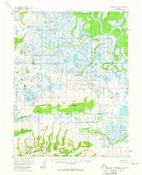
1955 Map of Shungnak D-4
USGS Topo · Published 1965About this map
The Kobuk River snakes through a complex network of wetlands and tundra in this mid-century survey of the Alaskan interior. The landscape is dominated by the massive Sheklukshuk Range to the south and the prominent Shaleruckik Mountain in the center, which serves as a topographic anchor amidst the surrounding lowlands. Sparse human presence is evidenced only by an occasional Cabin, suggesting a wilderness used primarily for seasonal subsistence or trapping rather than permanent settlement.
Find a feature on this map
11 named features on this map. Tap any name to fly to it.
Don’t see what you’re looking for? This feature index may not catch every label — zoom into the map to look around manually.
Map Details
Editions of this 1955 Shungnak D-4 Map
2 editions found
Other maps of this area

1951 · Shungnak
USGS Topo · 1:250,000

1951 · Ambler River
USGS Topo · 1:250,000

1955 · Shungnak
USGS Topo · 1:250,000

1955 · Ambler River A-4
USGS Topo · 1:63,360

1955 · Shungnak D-4
USGS Topo · 1:63,360

1955 · Shungnak D-5
USGS Topo · 1:63,360

1955 · Shungnak D-3
USGS Topo · 1:63,360

1955 · Ambler River A-5
USGS Topo · 1:63,360

1956 · Ambler River
USGS Topo · 1:250,000

1964 · Shungnak
USGS Topo · 1:250,000