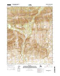
2015 Map of Shungnak D-6 NW
USGS Topo · Published 2015About this map
Kobuk Valley National Park encompasses the northern portion of this Alaskan landscape, where the Waring Mountains rise above a complex network of waterways. The drainage pattern is defined by the Nuleargowik River and several significant creeks, including Kuchuk Cr and Niaktugik Cr. This 2015 survey reflects a wilderness area primarily managed under federal and state jurisdictions, with the terrain marked by significant elevation changes across the Waring Mountains range. The map provides a detailed view of the natural hydrology, tracing the paths of Kavet Cr and its tributaries as they move through the varied topography of the Northwest Arctic Borough. The lack of roads or settlements underscores the remote, protected character of the parkland at the time of this publication.
Find a feature on this map
15 named features on this map. Tap any name to fly to it.
Don’t see what you’re looking for? This feature index may not catch every label — zoom into the map to look around manually.
Map Details
Editions of this 2015 Shungnak D-6 NW Map
This is the sole edition of this map. No revisions or reprints were ever made.
Other maps of this area

1951 · Baird Mountains
USGS Topo · 1:250,000

1951 · Selawik
USGS Topo · 1:250,000

1951 · Shungnak
USGS Topo · 1:250,000

1951 · Ambler River
USGS Topo · 1:250,000

1955 · Shungnak
USGS Topo · 1:250,000

1955 · Baird Mountains A-1
USGS Topo · 1:63,360

1955 · Ambler River A-6
USGS Topo · 1:63,360

1955 · Shungnak D-6
USGS Topo · 1:63,360
1955 · Selawik D-1
USGS Topo · 1:63,360

1956 · Ambler River
USGS Topo · 1:250,000