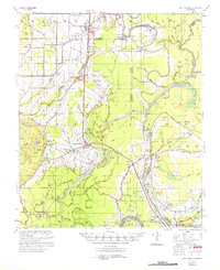
1957 Map of Sicily Island
USGS Topo · Published 1974About this map
The town of Sicily Island serves as the central hub for this corner of Catahoula Parish, situated on an elevated terrace above the complex network of bayous and wetlands. The landscape is defined by the winding course of the Tensas River and the numerous landings that once facilitated trade along its banks, including Crescent Ldg and Denmark Ldg. The presence of the Missouri Pacific Line indicates the importance of rail transport to the local economy, connecting smaller settlements like Wisner and Foules to regional markets.
Find a feature on this map
161 named features on this map. Tap any name to fly to it.
Don’t see what you’re looking for? This feature index may not catch every label — zoom into the map to look around manually.
Map Details
Editions of this 1957 Sicily Island Map
2 editions found

Other maps of this area

1921 · Natchez
USGS Topo · 1:48,000

1922 · Natchez
USGS Topo · 1:62,500

1935 · Winnsboro
USGS Topo · 1:62,500

1935 · Shackleford Lake
USGS Topo · 1:62,500

1939 · Red Gum
USGS Topo · 1:62,500

1939 · Fort Necessity
USGS Topo · 1:62,500

1939 · Natchez
USGS Topo · 1:62,500

1939 · Locust Ridge
USGS Topo · 1:62,500

1941 · Manifest
USGS Topo · 1:62,500

1941 · Sicily Island
USGS Topo · 1:62,500