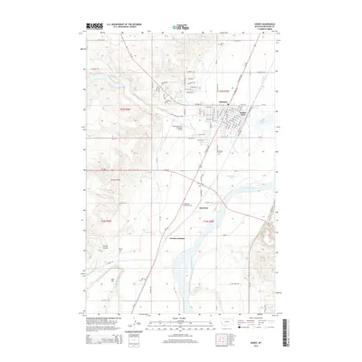
2014 Map of Sidney
USGS Topo · Published 2014About this map
Sidney serves as the focal point of this Eastern Montana landscape, situated along the western banks of the Yellowstone River. The town's layout is meticulously detailed, showing the street grid from W Main St to the residential developments along Pishkin Dr and Sunflower Ln. Significant civic landmarks include Fischer Park and the nearby Sidney-Richland Municipal Airport. To the south, the map reveals the smaller communities of Riverview and Newlon Junction, tracing the relationship between these settlements and the vital water management systems of the Main Canal. Local history and genealogy are well-represented by several burial grounds, including Sidney Cem, Pioneer Cem, and Newlon Cem. The physical geography is defined by the river’s floodplain and the rising elevations of Bell Hill, while several springs like 22N59E09BA_01 Spring dot the outlying coulees, indicating the importance of water sources in this prairie environment.
Find a feature on this map
98 named features on this map. Tap any name to fly to it.
Don’t see what you’re looking for? This feature index may not catch every label — zoom into the map to look around manually.
Map Details
Editions of this 2014 Sidney Map
This is the sole edition of this map. No revisions or reprints were ever made.
Other maps of this area

1909 · Glendive
USGS Topo · 1:250,000

1954 · Glendive
USGS Topo · 1:250,000

1957 · Glendive
USGS Topo · 1:250,000

1958 · Glendive
USGS Topo · 1:250,000

1966 · Crane NE
USGS Topo · 1:24,000

1966 · Piche
USGS Topo · 1:24,000

1966 · Crane
USGS Topo · 1:24,000

1966 · Sidney NE
USGS Topo · 1:24,000

1966 · Sidney
USGS Topo · 1:24,000

1972 · Brorson
USGS Topo · 1:24,000