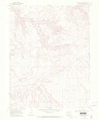
1968 Map of Sieber Canyon
USGS Topo · Published 1972About this map
Deep incisions of the Little Dolores River carve through this high desert plateau, revealing a complex network of drainage systems typical of the Colorado landscape. In the late 1960s, the terrain was defined by significant formations like Long Mesa and the converging paths of Knowles Canyon and Sieber Canyon. The map records a landscape predominantly used for transit and resource extraction, evidenced by the presence of a Quarry and a network of Jeep Trails that navigate the ridges between Jones Canyon and Toms Canyon. This topography highlights the hydrological patterns of the western slope, particularly near Twentyeight Hole Wash and Mee Canyon, where the surface is shaped by seasonal runoff patterns. The proximity to the state line suggests a remote area where traditional ranching and surveying access routes remained the primary marks of human activity.
Find a feature on this map
14 named features on this map. Tap any name to fly to it.
Don’t see what you’re looking for? This feature index may not catch every label — zoom into the map to look around manually.
Map Details
Editions of this 1968 Sieber Canyon Map
2 editions found
Other maps of this area

1885 · East Tavaputs
USGS Topo · 1:250,000

1885 · La Sal
USGS Topo · 1:250,000

1954 · Mt. Waas 1 NE
USGS Topo · 1:24,000

1954 · Coates Creek
USGS Topo · 1:62,500

1956 · Westwater 4 SE
USGS Topo · 1:24,000

1956 · Moab
USGS Topo · 1:250,000

1956 · Grand Junction
USGS Topo · 1:250,000

1959 · Grand Junction
USGS Topo · 1:250,000

1959 · Moab
USGS Topo · 1:250,000

1960 · Moab
USGS Topo · 1:250,000