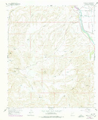
1959 Map of Sierra Alta
USGS Topo · Published 1979About this map
Rincon Valley serves as a stark, fertile contrast to the surrounding desert uplands in this detailed 1959 study of southern New Mexico. The Rio Grande winds along the eastern edge, bordered by specialized irrigation infrastructure including the Rincon Lateral and a Private Drain. This agricultural corridor supported several family-named outposts, such as the Haynor Ranch and its associated Cem, reflecting the local-history importance of the river for settlement.
Find a feature on this map
37 named features on this map. Tap any name to fly to it.
Don’t see what you’re looking for? This feature index may not catch every label — zoom into the map to look around manually.
Map Details
Editions of this 1959 Sierra Alta Map
Other maps of this area

1891 · Las Cruces
USGS Topo · 1:125,000

1893 · Las Cruces
USGS Topo · 1:125,000

1916 · Tonuco
USGS Topo · 1:125,000

1932 · Tonuco
USGS Topo · 1:125,000

1941 · Las Cruces
USGS Topo · 1:62,500

1943 · Corralitos Ranch
USGS Topo · 1:62,500

1943 · Las Cruces
USGS Topo · 1:62,500

1948 · San Diego Mountain
USGS Topo · 1:62,500

1955 · Las Cruces
USGS Topo · 1:250,000

1958 · Las Cruces
USGS Topo · 1:250,000