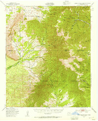
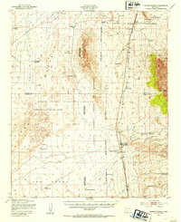
1950 Map of Sierra Blanca Peak
USGS Topo · Published 1955About this map
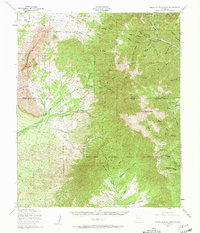
Sacramento Mountains dominance defines this high-altitude survey, anchored by the massive bulk of Sierra Blanca Peak. At the midpoint of the twentieth century, this landscape remains largely defined by its protected status, split between the northern reaches of the Mescalero Apache Indian Reservation and the southern extension of the Lincoln National Forest. The map documents a complex drainage system where the headwaters of the Rio Bonito and Rio Ruidoso flow eastward, while Three Rivers descends the western slopes toward the basin. The detail includes numerous springs and canyons like Cienegita Spring and Argentina Canyon, reflecting the vital water sources required for life in these high timberlands. Isolated landmarks such as Nogal Peak and Black Mountain stand as sentinels over the diverse terrain of ridges and draws.
Find a feature on this map
44 named features on this map. Tap any name to fly to it.
Don’t see what you’re looking for? This feature index may not catch every label — zoom into the map to look around manually.
Map Details
Editions of this 1950 Sierra Blanca Peak Map
2 editions found
Other maps of this area

1916 · Tularosa
USGS Topo · 1:125,000

1918 · Oscura Peak
USGS Topo · 1:125,000

1934 · Capitan
USGS Topo · 1:48,000

1937 · Capitan
USGS Topo · 1:62,500
1938 · Carrizozo
USGS Topo · 1:48,000
1943 · Carrizozo
USGS Topo · 1:62,500
1947 · Three Rivers
USGS Topo · 1:62,500

1948 · Chihuahua Ranch
USGS Topo · 1:62,500
1948 · Tularosa
USGS Topo · 1:62,500
1950 · Three Rivers
USGS Topo · 1:24,000