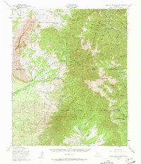
1950 Map of Sierra Blanca Peak
USGS Topo · Published 1962About this map
Sierra Blanca Peak dominates this high-altitude landscape along the border of the Mescalero Apache Indian Reservation and the Lincoln National Forest. The map details the intricate watershed of the Sacramento Mountains, where the North Fork Rio Ruidoso and South Fork Rio Ruidoso begin their descent. This mid-century survey reveals a transition from the rugged mountain heights to the desert drainage systems of Three Rivers and Golondrina Draw. Local landmarks like Nogal Peak and Black Mountain define the horizon, while smaller features such as Cienegita Spring and Sulphur Spring indicate critical water sources in this arid environment. The map also records the winding paths of Rio Bonito and Eagle Creek, illustrating the natural barriers and resources that shaped the settlement of Otero and Lincoln counties.
Find a feature on this map
43 named features on this map. Tap any name to fly to it.
Don’t see what you’re looking for? This feature index may not catch every label — zoom into the map to look around manually.
Map Details
Editions of this 1950 Sierra Blanca Peak Map
2 editions found

Other maps of this area

1916 · Tularosa
USGS Topo · 1:125,000

1918 · Oscura Peak
USGS Topo · 1:125,000

1934 · Capitan
USGS Topo · 1:48,000

1937 · Capitan
USGS Topo · 1:62,500

1938 · Carrizozo
USGS Topo · 1:48,000

1943 · Carrizozo
USGS Topo · 1:62,500

1947 · Three Rivers
USGS Topo · 1:62,500

1948 · Chihuahua Ranch
USGS Topo · 1:62,500

1948 · Tularosa
USGS Topo · 1:62,500

1950 · Three Rivers
USGS Topo · 1:24,000