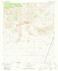
1961 Map of Sierra Fijardo
USGS Topo · Published 1981About this map
The Cibola National Forest landscape across the Socorro and Sierra County line is defined by a complex network of arid canyons and high ridges. The map illustrates the isolated infrastructure required for ranching in the high desert, centered around the Flying X Ranch and the H Bierner No 2 Res reservoir. Water sources are critical landmarks here, appearing as Deer Springs, Peñasco Spring, and several named tanks and wells like the Marcus Tank and Los Pillares Well.
Find a feature on this map
38 named features on this map. Tap any name to fly to it.
Don’t see what you’re looking for? This feature index may not catch every label — zoom into the map to look around manually.
Map Details
Editions of this 1961 Sierra Fijardo Map
2 editions found
Other maps of this area

1954 · Tularosa
USGS Topo · 1:250,000

1958 · Tularosa
USGS Topo · 1:250,000

1961 · Priest Tank
USGS Topo · 1:24,000

1961 · Huerfano Hill
USGS Topo · 1:24,000

1961 · Sierra Fijardo
USGS Topo · 1:24,000

1961 · Black Bluffs
USGS Topo · 1:24,000

1961 · Black Hill
USGS Topo · 1:24,000

1961 · Monticello
USGS Topo · 1:24,000

1961 · Romero Canyon
USGS Topo · 1:24,000

1964 · Vicks Peak
USGS Topo · 1:24,000