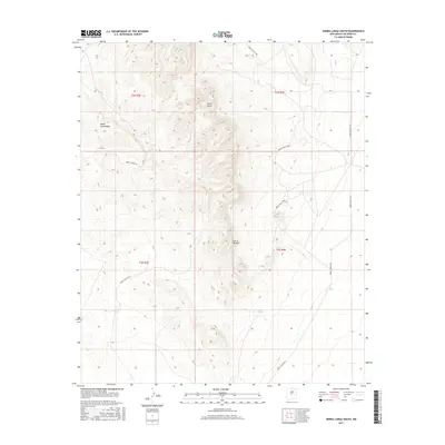
2017 Map of Sierra Larga South
USGS Topo · Published 2017About this map
Sierra Larga dominates this 2017 high-desert landscape in Socorro County, where significant topographic elevations like Cerro Venado and the ridgeline of Bordo Atravesado define the local geography. This area is characterized by its integration into the White Sands Missile Range infrastructure, as evidenced by the network of numbered routes including WSMR S Route 3803 and WSMR S Route 3617. These roads provide the primary access through the arid terrain, connecting isolated water sources such as Coyote Spring to the broader regional grid. The map reflects a modern surveying of public land boundaries, clearly marking the townships and ranges like t3s r3e and t3s r4e. For the historian or researcher, this sheet provides a clear look at how military land management preserves the physical landscape, documenting the precise location of springs and the specialized road systems required for remote desert navigation.
Find a feature on this map
12 named features on this map. Tap any name to fly to it.
Don’t see what you’re looking for? This feature index may not catch every label — zoom into the map to look around manually.
Map Details
Editions of this 2017 Sierra Larga South Map
This is the sole edition of this map. No revisions or reprints were ever made.
Other maps of this area

1916 · La Joya
USGS Topo · 1:125,000

1918 · Oscura Peak
USGS Topo · 1:125,000

1948 · Carthage
USGS Topo · 1:62,500

1948 · Bingham
USGS Topo · 1:62,500

1954 · Tularosa
USGS Topo · 1:250,000

1954 · Socorro
USGS Topo · 1:250,000

1958 · Socorro
USGS Topo · 1:250,000

1958 · Tularosa
USGS Topo · 1:250,000

1962 · Socorro
USGS Topo · 1:250,000
1972 · Sierra Larga North
USGS Topo · 1:24,000