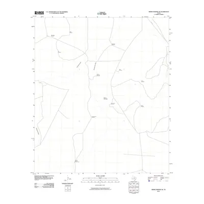
2010 Map of Sierra Madera NE
USGS Topo · Published 2010About this map
Kelly Wade Windmill and several other water-sourcing landmarks define this arid Pecos County landscape during the early 21st century. The terrain is structured by ephemeral watercourses such as Sixshooter Draw and Number Four Draw, which channel seasonal runoff through the region. This survey highlights the critical role of ranching infrastructure in West Texas, where family-named and descriptive features like Lemon Windmill Number One and Twenty Foot Windmill are vital points of reference in an otherwise sparse environment.
Find a feature on this map
15 named features on this map. Tap any name to fly to it.
Don’t see what you’re looking for? This feature index may not catch every label — zoom into the map to look around manually.
Map Details
Editions of this 2010 Sierra Madera NE Map
This is the sole edition of this map. No revisions or reprints were ever made.
Other maps of this area

1921 · Fort Stockton
USGS Topo · 1:62,500

1923 · Fort Stockton
USGS Topo · 1:62,500

1923 · Sierra Madera
USGS Topo · 1:62,500

1928 · Comanche Spring
USGS Topo · 1:125,000

1954 · Fort Stockton
USGS Topo · 1:250,000

1958 · Fort Stockton
USGS Topo · 1:250,000

1970 · Twelvemile Mesa
USGS Topo · 1:24,000
1970 · East Mesa SW
USGS Topo · 1:24,000
1970 · Fivemile Mesa
USGS Topo · 1:24,000

1973 · Fort Stockton
USGS Topo · 1:250,000