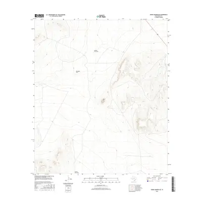
2016 Map of Sierra Madera NE
USGS Topo · Published 2016About this map
Round Mtn stands as a prominent landmark in this section of Pecos County, characterized by the arid drainage systems of the Trans-Pecos region. The landscape is defined by the ephemeral watercourses of Number Four Draw and Sixshooter Draw, which illustrate the natural irrigation and erosion patterns typical of west Texas ranching country. This 2016 survey reflects the sparse human footprint in this corner of the state, highlighting the importance of named topographic features for navigation and land management. Researchers can examine the intricate contour work that reveals the gradual elevation changes across these broad draws and isolated rises.
Find a feature on this map
3 named features on this map. Tap any name to fly to it.
Don’t see what you’re looking for? This feature index may not catch every label — zoom into the map to look around manually.
Map Details
Editions of this 2016 Sierra Madera NE Map
This is the sole edition of this map. No revisions or reprints were ever made.
Other maps of this area

1921 · Fort Stockton
USGS Topo · 1:62,500

1923 · Fort Stockton
USGS Topo · 1:62,500

1923 · Sierra Madera
USGS Topo · 1:62,500

1928 · Comanche Spring
USGS Topo · 1:125,000

1954 · Fort Stockton
USGS Topo · 1:250,000

1958 · Fort Stockton
USGS Topo · 1:250,000

1970 · Twelvemile Mesa
USGS Topo · 1:24,000
1970 · East Mesa SW
USGS Topo · 1:24,000
1970 · Fivemile Mesa
USGS Topo · 1:24,000

1973 · Fort Stockton
USGS Topo · 1:250,000