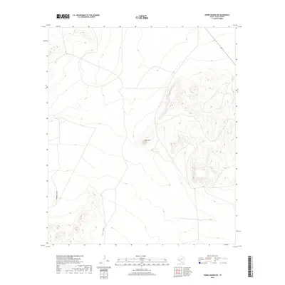
2019 Map of Sierra Madera NE
USGS Topo · Published 2019About this map
Round Mtn rises as a central topographic landmark within this West Texas landscape, surrounded by a complex network of seasonal drainages typical of the Pecos County high desert. The terrain is defined by the significant passage of Sixshooter Draw in the western reaches and Number Four Draw to the south, highlighting the natural hydrological patterns that dictate movement across this arid region. The eastern portion of the sheet is marked by the rugged slopes of the Sierra Madera, where the contour lines tighten significantly compared to the broader alluvial plains. Modern infrastructure is limited to the corridor of Highway 285, which cuts through the northeastern corner, providing the primary arterial connection through this sparsely settled territory.
Find a feature on this map
4 named features on this map. Tap any name to fly to it.
Don’t see what you’re looking for? This feature index may not catch every label — zoom into the map to look around manually.
Map Details
Editions of this 2019 Sierra Madera NE Map
This is the sole edition of this map. No revisions or reprints were ever made.
Other maps of this area

1921 · Fort Stockton
USGS Topo · 1:62,500

1923 · Fort Stockton
USGS Topo · 1:62,500

1923 · Sierra Madera
USGS Topo · 1:62,500

1928 · Comanche Spring
USGS Topo · 1:125,000

1954 · Fort Stockton
USGS Topo · 1:250,000

1958 · Fort Stockton
USGS Topo · 1:250,000

1970 · Twelvemile Mesa
USGS Topo · 1:24,000
1970 · East Mesa SW
USGS Topo · 1:24,000
1970 · Fivemile Mesa
USGS Topo · 1:24,000

1973 · Fort Stockton
USGS Topo · 1:250,000