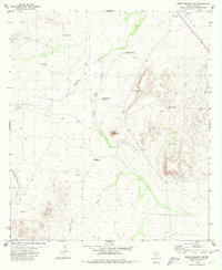
1980 Map of Sierra Madera NE
USGS Topo · Published 1980About this map
Round Mountain stands as a prominent topographical anchor in this arid Pecos County landscape, where survival and movement are defined by scarce water sources and expansive drainage systems. The map illustrates a ranching economy reliant on scattered infrastructure, specifically a network of family-named or descriptive water features such as Weak Windmill, Sixshooter Windmill, and Red Well. These points, along with the intermittent courses of Sixshooter Draw and Four Number Draw, provide a window into the logistical realities of West Texas land use in the mid-1970s. Industrial activity is present through scattered Drill Holes and a Gravel Pit in the northern section, while a remote Landing Strip suggests the vast distances required for aerial transport in this part of the Trans-Pecos region.
Find a feature on this map
18 named features on this map. Tap any name to fly to it.
Don’t see what you’re looking for? This feature index may not catch every label — zoom into the map to look around manually.
Map Details
Editions of this 1980 Sierra Madera NE Map
This is the sole edition of this map. No revisions or reprints were ever made.
Other maps of this area

1921 · Fort Stockton
USGS Topo · 1:62,500

1923 · Fort Stockton
USGS Topo · 1:62,500

1923 · Sierra Madera
USGS Topo · 1:62,500

1928 · Comanche Spring
USGS Topo · 1:125,000

1954 · Fort Stockton
USGS Topo · 1:250,000

1958 · Fort Stockton
USGS Topo · 1:250,000

1970 · Twelvemile Mesa
USGS Topo · 1:24,000
1970 · East Mesa SW
USGS Topo · 1:24,000
1970 · Fivemile Mesa
USGS Topo · 1:24,000

1973 · Fort Stockton
USGS Topo · 1:250,000