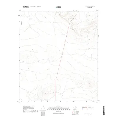
2019 Map of Sierra Madera NW
USGS Topo · Published 2019About this map
The arid Pecos County landscape is defined by its drainage patterns and water management features, dominated by the long north-south route of highway 385. The topography is marked by significant ephemeral watercourses, including Belding Draw in the northwest and Sixshooter Draw in the southeast, which illustrate the natural watershed of this high desert terrain. Local ranching or livestock infrastructure is evidenced by specifically named water catchments like West Tank and Corner Tank, which are vital landmarks in an otherwise sparse environment. The presence of Esca Lera Rd provides one of the few named access points into the undulating terrain, where elevation contours reveal a series of ridges and basins typical of this part of West Texas.
Find a feature on this map
6 named features on this map. Tap any name to fly to it.
Don’t see what you’re looking for? This feature index may not catch every label — zoom into the map to look around manually.
Map Details
Editions of this 2019 Sierra Madera NW Map
This is the sole edition of this map. No revisions or reprints were ever made.
Other maps of this area

1921 · Fort Stockton
USGS Topo · 1:62,500

1923 · Fort Stockton
USGS Topo · 1:62,500

1923 · Sierra Madera
USGS Topo · 1:62,500

1928 · Comanche Spring
USGS Topo · 1:125,000

1929 · Hovey
USGS Topo · 1:125,000

1954 · Fort Stockton
USGS Topo · 1:250,000

1958 · Fort Stockton
USGS Topo · 1:250,000

1970 · Twelvemile Mesa
USGS Topo · 1:24,000
1970 · Fivemile Mesa
USGS Topo · 1:24,000
1970 · Belding
USGS Topo · 1:24,000