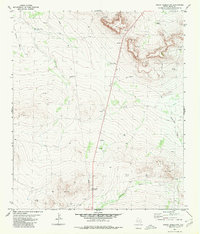
1980 Map of Sierra Madera NW
USGS Topo · Published 1980About this map
Industrial infrastructure and desert hydrology characterize this 1980 landscape in Pecos County. The Pikes Peak Gas Plant stands as a primary landmark in the southern portion of the quadrangle, connected to a prominent pipeline that traverses the terrain. This area, located between Fort Stockton and Marathon, reveals a reliance on groundwater and resource extraction. Named water features like Belding Draw and Sixshooter Draw cut through the topography, while numerous water sources such as the Puckett Windmill, Red Bed Well, and West Tank highlight the necessity of water management in this arid environment. Scattered drill holes and gravel pits further indicate the mid-20th-century development of the region's mineral and gas resources.
Find a feature on this map
18 named features on this map. Tap any name to fly to it.
Don’t see what you’re looking for? This feature index may not catch every label — zoom into the map to look around manually.
Map Details
Editions of this 1980 Sierra Madera NW Map
This is the sole edition of this map. No revisions or reprints were ever made.
Other maps of this area

1921 · Fort Stockton
USGS Topo · 1:62,500

1923 · Fort Stockton
USGS Topo · 1:62,500

1923 · Sierra Madera
USGS Topo · 1:62,500

1928 · Comanche Spring
USGS Topo · 1:125,000

1929 · Hovey
USGS Topo · 1:125,000

1954 · Fort Stockton
USGS Topo · 1:250,000

1958 · Fort Stockton
USGS Topo · 1:250,000

1970 · Twelvemile Mesa
USGS Topo · 1:24,000
1970 · Fivemile Mesa
USGS Topo · 1:24,000
1970 · Belding
USGS Topo · 1:24,000