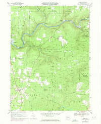
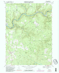
1967 Map of Sigel
USGS Topo · Published 1973About this map
Clarion River winds through the northern reaches of this territory, defining a landscape of deep valleys and dense woodland within the Allegheny National Forest. The 1960s economy of this region is clearly visible through the extensive network of gas wells and pipelines that dominate the ridges above Little Clear Creek and Millstone Creek. In the southern portion, the crossroads settlement of Sigel serves as a hub for local travel, while Clarington sits at the river's edge. Recreational and conservation land use is prominent, with Clear Creek State Park and Kittanning State Forest preserving the timbered uplands. Notable landmarks for local historians include Mt Tabor Cem, the Heath Pumping Station, and the distinct elevation of Stahlman Roundtop, offering a detailed view of the interaction between natural resource extraction and state-managed wilderness.
Find a feature on this map
2 named features on this map. Tap any name to fly to it.
Don’t see what you’re looking for? This feature index may not catch every label — zoom into the map to look around manually.
Map Details
Editions of this 1967 Sigel Map
5 editions found
Other maps of this area

1918 · Loleta
USGS Topo · 1:62,500

1922 · Du Bois
USGS Topo · 1:62,500

1924 · Du Bois
USGS Topo · 1:62,500

1924 · Brookville
USGS Topo · 1:62,500

1926 · Brookville
USGS Topo · 1:62,500

1936 · Marienville
USGS Topo · 1:48,000

1940 · Hallton
USGS Topo · 1:48,000

1941 · Marienville
USGS Topo · 1:62,500

1943 · Hallton
USGS Topo · 1:62,500

1944 · Du Bois
USGS Topo · 1:62,500
Featured Places
- Warsaw Township, PA
- Millstone Township, PA
- Polk Township, PA
- Clarington, Barnett Township
- Eldred Township, PA