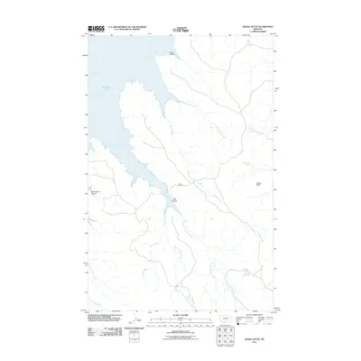
2011 Map of Signal Butte
USGS Topo · Published 2011About this map
Fort Peck Lake dominates the western edge of this landscape, its indented shoreline giving way to the high, broken plains of Valley County. In the eastern portion of the quadrangle, Signal Butte stands as a prominent landmark above a network of drainage features including Swallow Nest Spring and Rough Sheep Creek. The map documents a sparsely populated ranching environment, centered on the Cole Ranch and the intricate coulees that feed into the lake, such as Bog Coulee and White Horse Coulee. This 2011 survey captures the hydrological complexity of the Missouri River basin's tributaries, showing how seasonal drainages like Cattle Creek and the East Fork Crooked Creek define the movements of both water and livestock across the prairie.
Find a feature on this map
13 named features on this map. Tap any name to fly to it.
Don’t see what you’re looking for? This feature index may not catch every label — zoom into the map to look around manually.
Map Details
Editions of this 2011 Signal Butte Map
This is the sole edition of this map. No revisions or reprints were ever made.
Other maps of this area

1954 · Jordan
USGS Topo · 1:250,000

1956 · Jordan
USGS Topo · 1:250,000

1958 · Jordan
USGS Topo · 1:250,000

1958 · Collins Ranch
USGS Topo · 1:62,500

1958 · Maloney Hill
USGS Topo · 1:62,500

1958 · Sage Creek Point
USGS Topo · 1:24,000
1958 · Seventh Point Buttes
USGS Topo · 1:24,000

1964 · Jordan
USGS Topo · 1:250,000
1972 · Kester School
USGS Topo · 1:24,000
1972 · Gilbert Creek SE
USGS Topo · 1:24,000