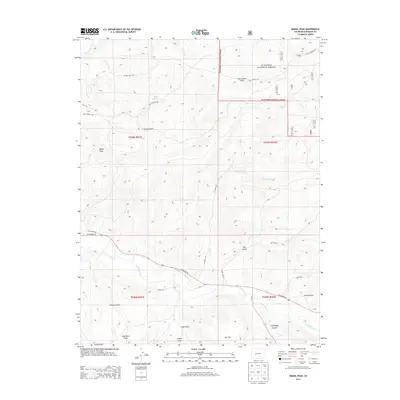
2013 Map of Signal Peak
USGS Topo · Published 2013About this map
Signal Peak rises as a prominent landmark in this high-altitude landscape of central Colorado, where the sprawling Gunnison National Forest meets a network of vital waterways and historical ranching corridors. The drainage pattern is anchored by the Gunnison River in the northwest and Tomichi Creek cutting through the southern plains, joined by smaller tributaries like Cochetopa Cr and Cabin Cr. This topography, marked by numerous dry draws such as Sage Hen Gulch and Chance Gulch, reflects a transition from forested uplands to the semi-arid valleys. The presence of Old Highway 50 and Winze Rd alongside modern US Highway 50 traces the evolution of transportation through these mountain passes. Points of local significance like Biebel Springs and the geological formation of Cochetopa Canyon highlight the natural features that have guided land use and travel for generations in Gunnison County.
Find a feature on this map
29 named features on this map. Tap any name to fly to it.
Don’t see what you’re looking for? This feature index may not catch every label — zoom into the map to look around manually.
Map Details
Editions of this 2013 Signal Peak Map
This is the sole edition of this map. No revisions or reprints were ever made.
Other maps of this area

1941 · Pitkin
USGS Topo · 1:62,500

1945 · Pitkin
USGS Topo · 1:62,500

1954 · Iris NW
USGS Topo · 1:24,000

1954 · Gunnison
USGS Topo · 1:24,000

1956 · Montrose
USGS Topo · 1:250,000

1959 · Montrose
USGS Topo · 1:250,000

1960 · Montrose
USGS Topo · 1:250,000

1962 · Iris
USGS Topo · 1:24,000

1962 · Houston Gulch
USGS Topo · 1:24,000
1964 · Flat Top
USGS Topo · 1:24,000