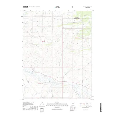
2019 Map of Signal Peak
USGS Topo · Published 2019About this map
Gunnison National Forest land dominates the northern and eastern portions of this Colorado landscape, where high plateaus give way to deep drainages. The area is defined by massive landforms like Signal Peak and the dual elevations of Signal Mesa W and Signal Mesa E. A complex system of waterways and canyons shapes the topography, most notably the winding path of Tomichi Creek and the steep walls of Cochetopa Canyon in the south. These natural corridors have historically influenced local movement, now reflected in the network of rural routes such as Co RD 743 and BLM RD 3107 - Cabin CRK. Smaller water sources like Biebel Springs provide critical points of interest within the drier uplands, while several named gulches, including Lost Canyon Gulch and Chance Gulch, highlight the erosion patterns characteristic of the Gunnison River basin.
Find a feature on this map
33 named features on this map. Tap any name to fly to it.
Don’t see what you’re looking for? This feature index may not catch every label — zoom into the map to look around manually.
Map Details
Editions of this 2019 Signal Peak Map
This is the sole edition of this map. No revisions or reprints were ever made.
Other maps of this area

1941 · Pitkin
USGS Topo · 1:62,500

1945 · Pitkin
USGS Topo · 1:62,500

1954 · Iris NW
USGS Topo · 1:24,000

1954 · Gunnison
USGS Topo · 1:24,000

1956 · Montrose
USGS Topo · 1:250,000

1959 · Montrose
USGS Topo · 1:250,000

1960 · Montrose
USGS Topo · 1:250,000

1962 · Iris
USGS Topo · 1:24,000

1962 · Houston Gulch
USGS Topo · 1:24,000
1964 · Flat Top
USGS Topo · 1:24,000