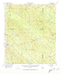
1954 Map of Sikes
USGS Topo · Published 1974About this map
Sikes sits at the intersection of local rail and road networks in the mid-1950s, serving as a hub for this timber-rich region of Northern Louisiana. The landscape is defined by the Louisiana Meridian and the convergence of Jackson, Winn, and Caldwell Parishes. While the town of Sikes is the primary population center, the surrounding countryside is dotted with small rural communities and family-named landmarks. Numerous spiritual and educational centers are mapped, including Fellowship Ch, Old Union Ch, and the Brister Sch. Industrial and safety infrastructure is evident through the Quarry near Womack and elevated observation points like the Heads Mill Lookout Tower and Sikes Lookout Tower. The drainage patterns of Castor Creek and Bear Creek suggest a terrain heavily influenced by the winding branches and creeks that cross parish lines.
Find a feature on this map
105 named features on this map. Tap any name to fly to it.
Don’t see what you’re looking for? This feature index may not catch every label — zoom into the map to look around manually.
Map Details
Editions of this 1954 Sikes Map
4 editions found
Other maps of this area

1940 · Monroe
USGS Topo · 1:62,500

1940 · Columbia
USGS Topo · 1:62,500

1949 · Jonesboro
USGS Topo · 1:62,500

1950 · Jonesboro
USGS Topo · 1:62,500

1950 · Winnfield
USGS Topo · 1:62,500

1951 · Winnfield
USGS Topo · 1:62,500

1953 · Chatham
USGS Topo · 1:62,500

1953 · Hodge
USGS Topo · 1:62,500

1953 · Alexandria
USGS Topo · 1:250,000

1954 · Sikes
USGS Topo · 1:62,500