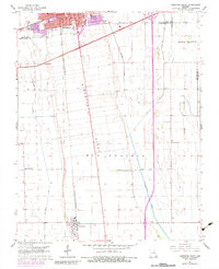
1963 Map of Sikeston South
USGS Topo · Published 1983About this map
The agricultural landscape of the Missouri Bootheel is defined here by the meeting of Sikeston and Matthews, where the flat terrain of Big Prairie and Long Prairie is crisscrossed by an extensive drainage network including North Cut Ditch and St Johns Ditch. The 1960s footprint of Sikeston shows significant southern expansion, marked by institutional landmarks like Lincoln Sch and South Sch. The area’s economic reliance on transportation is evident in the dual presence of the Missouri Pacific and the St Louis - San Francisco rail lines.
Find a feature on this map
26 named features on this map. Tap any name to fly to it.
Don’t see what you’re looking for? This feature index may not catch every label — zoom into the map to look around manually.
Map Details
Editions of this 1963 Sikeston South Map
Other maps of this area

1931 · Sikeston
USGS Topo · 1:62,500

1934 · Sikeston
USGS Topo · 1:62,500

1939 · Sikeston
USGS Topo · 1:62,500

1939 · Charleston
USGS Topo · 1:62,500

1939 · New Madrid
USGS Topo · 1:62,500

1939 · Bayouville
USGS Topo · 1:62,500

1954 · Charleston
USGS Topo · 1:62,500

1954 · New Madrid
USGS Topo · 1:62,500

1955 · Bayouville
USGS Topo · 1:62,500

1956 · Dyersburg
USGS Topo · 1:250,000