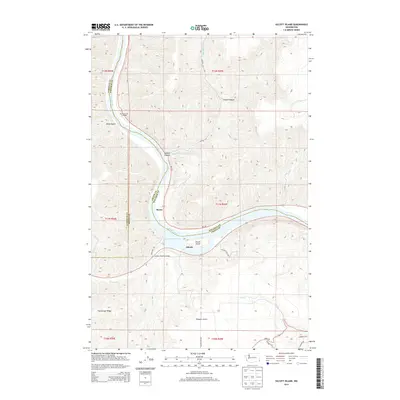
2014 Map of Silcott Island
USGS Topo · Published 2014About this map
Lower Granite Lake and the winding Snake River dominate this landscape where Asotin, Garfield, and Whitman counties converge. The geography is defined by deep incisions into the plateau, such as Steptoe Canyon and Stuart Canyon, which channel water toward the river valley. Small riverfront sites like Silcott and Moses sit along the southern bank, connected by Indian Timothy Bridge. South of the river, the terrain rises sharply toward Flerchinger Ridge, cut by the drainages of Alpowa Cr and Maguire Gulch. The map captures a transitional river environment where Silcott Island sits as a prominent feature within the reservoir-influenced waters of the Snake River, reflecting the modern hydrological management of this tri-county border region.
Find a feature on this map
33 named features on this map. Tap any name to fly to it.
Don’t see what you’re looking for? This feature index may not catch every label — zoom into the map to look around manually.
Map Details
Editions of this 2014 Silcott Island Map
This is the sole edition of this map. No revisions or reprints were ever made.
Other maps of this area

1910 · Pullman
USGS Topo · 1:125,000

1943 · Peola
USGS Topo · 1:62,500

1945 · Clarkston
USGS Topo · 1:62,500

1946 · Peola
USGS Topo · 1:62,500

1948 · Clarkston
USGS Topo · 1:62,500

1955 · Pullman
USGS Topo · 1:250,000

1958 · Pullman
USGS Topo · 1:250,000

1964 · Colton
USGS Topo · 1:24,000

1964 · Bishop
USGS Topo · 1:24,000
1964 · Uniontown
USGS Topo · 1:24,000