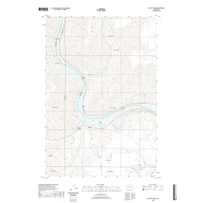
2020 Map of Silcott Island
USGS Topo · Published 2020About this map
The Snake River carves a deep path through this portion of the Pacific Northwest, where the borders of Whitman, Asotin, and Garfield counties converge at the water's edge. This modern survey illustrates the rugged river topography south of the Steptoe Canyon area, focusing on the small settlements of Silcott and Moses. A significant landmark in this riverine landscape is the Indian Timothy Bridge, which facilitates movement across the drainage near where Alpowa Cr meets the main channel. High elevation features like Flerchinger Ridge and numerous steep drainages, including Maguire Gulch and Sheep Gulch, define the surrounding canyon walls. The map reveals how local infrastructure like Silcott Grade Rd and Wawawai River Rd navigate the complex elevation changes between the river basin and the high plateau above.
Find a feature on this map
36 named features on this map. Tap any name to fly to it.
Don’t see what you’re looking for? This feature index may not catch every label — zoom into the map to look around manually.
Map Details
Editions of this 2020 Silcott Island Map
This is the sole edition of this map. No revisions or reprints were ever made.
Other maps of this area

1910 · Pullman
USGS Topo · 1:125,000

1943 · Peola
USGS Topo · 1:62,500

1945 · Clarkston
USGS Topo · 1:62,500

1946 · Peola
USGS Topo · 1:62,500

1948 · Clarkston
USGS Topo · 1:62,500

1955 · Pullman
USGS Topo · 1:250,000

1958 · Pullman
USGS Topo · 1:250,000

1964 · Colton
USGS Topo · 1:24,000

1964 · Bishop
USGS Topo · 1:24,000
1964 · Uniontown
USGS Topo · 1:24,000