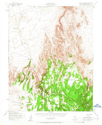
1952 Map of Silent Canyon
USGS Topo · Published 1965About this map
The Nellis Air Force Range dominates this mid-century landscape of Nye County, Nevada, where the desert floor meets the high plateau of Pahute Mesa. This survey reflects a period of military and geological assessment, highlighting isolated points of infrastructure like Gold Flat Well No 1 and an earthen Landing Strip positioned on the broad expanse of Gold Flat. The topography is defined by the dramatic drainage systems of Silent Canyon and its many branches, which cut deep into the mesa. Between these sharp ridges and canyons are high-altitude basins such as Dead Horse Flat and the ephemeral Dry Lake. The presence of Silent Butte and Basalt Ridge marks the transition from the relatively open flats to the complex, eroded terrain that characterized this remote government-managed territory during the early Cold War era.
Find a feature on this map
15 named features on this map. Tap any name to fly to it.
Don’t see what you’re looking for? This feature index may not catch every label — zoom into the map to look around manually.
Map Details
Editions of this 1952 Silent Canyon Map
3 editions found

Other maps of this area

1908 · Kawich
USGS Topo · 1:250,000

1942 · Tolicha Peak
USGS Topo · 1:125,000

1942 · Cactus Range
USGS Topo · 1:125,000

1942 · Reveille Peak
USGS Topo · 1:125,000

1942 · Wheelbarrow Peak
USGS Topo · 1:125,000

1952 · Mellan
USGS Topo · 1:62,500

1952 · Tippipah Spring
USGS Topo · 1:62,500

1952 · Quartzite Mtn
USGS Topo · 1:62,500

1952 · Timber Mountain
USGS Topo · 1:62,500

1952 · Wheelbarrow Peak
USGS Topo · 1:62,500