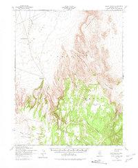
1952 Map of Silent Canyon
USGS Topo · Published 1981About this map
The Nellis Air Force Range occupies this high desert expanse in Nye County, showing the landscape as it appeared during the height of Cold War military surveying. The northern reaches are dominated by the level bed of Dry Lake and the broad expanse of Gold Flat, where a remote Landing Strip and a Bomb label point to the area's restricted tactical use. This 1952 topographic study, compiled by the Army Map Service, documents a transition from the volcanic tablelands of Pahute Mesa into complex drainage systems like North Silent Canyon and South Silent Canyon.
Find a feature on this map
20 named features on this map. Tap any name to fly to it.
Don’t see what you’re looking for? This feature index may not catch every label — zoom into the map to look around manually.
Map Details
Editions of this 1952 Silent Canyon Map
3 editions found

Other maps of this area

1908 · Kawich
USGS Topo · 1:250,000

1942 · Tolicha Peak
USGS Topo · 1:125,000

1942 · Cactus Range
USGS Topo · 1:125,000

1942 · Reveille Peak
USGS Topo · 1:125,000

1942 · Wheelbarrow Peak
USGS Topo · 1:125,000

1952 · Mellan
USGS Topo · 1:62,500

1952 · Tippipah Spring
USGS Topo · 1:62,500

1952 · Quartzite Mtn
USGS Topo · 1:62,500

1952 · Timber Mountain
USGS Topo · 1:62,500

1952 · Wheelbarrow Peak
USGS Topo · 1:62,500