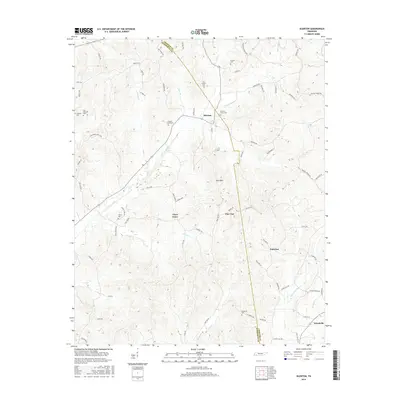
2016 Map of Silerton
USGS Topo · Published 2016About this map
Chickasaw State Park borders the northern reaches of this West Tennessee landscape, where the boundary between Chester and Hardeman counties divides a network of small farming communities and timbered ridges. The topography is defined by the drainages of Piney Creek and Greasy Creek, which flow through a terrain dotted with small settlements like Silerton and Palestine. For genealogists, the map is remarkably dense with burial grounds, including the Old Concord Cem, Hickory Grove Cem, and Coopers Chapel Cem, each reflecting the family-based settlement patterns of this region. Notable landmarks such as Ross Mtn and the numerous named branches like Sour Br and Hayes Br provide a detailed look at the local hydrology that historically shaped road placement and community borders in this part of the state.
Find a feature on this map
78 named features on this map. Tap any name to fly to it.
Don’t see what you’re looking for? This feature index may not catch every label — zoom into the map to look around manually.
Map Details
Editions of this 2016 Silerton Map
This is the sole edition of this map. No revisions or reprints were ever made.
Other maps of this area

1950 · Hebron
USGS Topo · 1:24,000

1950 · Hornsby
USGS Topo · 1:24,000

1951 · Hebron
USGS Topo · 1:24,000

1951 · Hornsby
USGS Topo · 1:24,000

1951 · Rose Creek
USGS Topo · 1:24,000

1956 · Blytheville
USGS Topo · 1:250,000

1959 · Blytheville
USGS Topo · 1:250,000

1961 · Medon
USGS Topo · 1:24,000
1961 · Silerton
USGS Topo · 1:24,000
1961 · Bolivar East
USGS Topo · 1:24,000