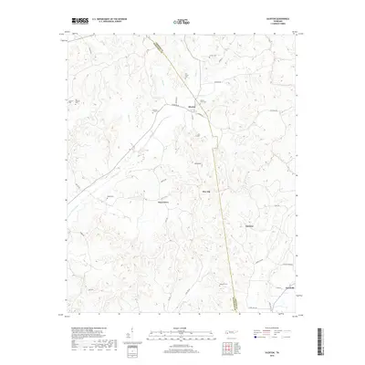
2019 Map of Silerton
USGS Topo · Published 2019About this map
Silerton and its surrounding communities sit at the intersection of Chester and Hardeman counties, a landscape defined by small settlements and numerous family and community burial grounds. This 2019 survey captures the quiet rural character of West Tennessee, where crossroads like Piney Grove, Palestine, and Woodville are linked by a network of local roads including Silerton Rd and Laurel Hill Rd. The terrain is marked by gentle elevations such as Ross Mtn and Pine Top, while the hydrological pattern is dominated by Piney Creek and its many tributaries like Little Piney Cr and Sour Br. Genealogists will find a wealth of local history in the high density of cemeteries, including Hickory Grove Cem, Antioch Cem, and Old Concord Cem, many of which remain as the primary landmarks of this agricultural region.
Find a feature on this map
38 named features on this map. Tap any name to fly to it.
Don’t see what you’re looking for? This feature index may not catch every label — zoom into the map to look around manually.
Map Details
Editions of this 2019 Silerton Map
This is the sole edition of this map. No revisions or reprints were ever made.
Other maps of this area

1950 · Hebron
USGS Topo · 1:24,000

1950 · Hornsby
USGS Topo · 1:24,000

1951 · Hebron
USGS Topo · 1:24,000

1951 · Hornsby
USGS Topo · 1:24,000

1951 · Rose Creek
USGS Topo · 1:24,000

1956 · Blytheville
USGS Topo · 1:250,000

1959 · Blytheville
USGS Topo · 1:250,000

1961 · Medon
USGS Topo · 1:24,000
1961 · Silerton
USGS Topo · 1:24,000
1961 · Bolivar East
USGS Topo · 1:24,000