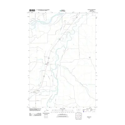
2011 Map of Silesia
USGS Topo · Published 2011About this map
The confluence of the Yellowstone River and the Clarks Fork Yellowstone River dominates this landscape, where a sophisticated network of irrigation channels supports the local agricultural economy. Features like the White Horse Canal, Glennwood Ditch, Smith Ditch, and Clawson Ditch trace the valley floor, illustrating the vital role of water management in this part of Carbon County. The small settlements of Silesia and Rockvale serve as focal points along the transportation corridor, with the Joliet Rural Fire Dist 1 Silesia Sta providing essential services to the rural community.
Find a feature on this map
42 named features on this map. Tap any name to fly to it.
Don’t see what you’re looking for? This feature index may not catch every label — zoom into the map to look around manually.
Map Details
Editions of this 2011 Silesia Map
This is the sole edition of this map. No revisions or reprints were ever made.
Other maps of this area

1954 · Billings
USGS Topo · 1:250,000

1956 · Silesia
USGS Topo · 1:24,000

1956 · Fromberg
USGS Topo · 1:24,000

1956 · Laurel
USGS Topo · 1:24,000

1956 · Park City
USGS Topo · 1:24,000

1956 · Edgar
USGS Topo · 1:24,000
1956 · Montaqua
USGS Topo · 1:24,000

1956 · Mossmain
USGS Topo · 1:24,000

1957 · Billings
USGS Topo · 1:250,000

1958 · Billings
USGS Topo · 1:250,000