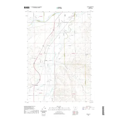
2020 Map of Silesia
USGS Topo · Published 2020About this map
Clarks Fork Yellowstone River dominates the landscape south of the main Yellowstone River confluence, carving a broad valley defined by an extensive network of irrigation infrastructure. This sophisticated water management system, including the Big Ditch, Mason Canal, Edgar Canal, and Free Silver Ditch, underpins the agricultural character of the region. The settlements of Silesia and Rockvale serve as focal points for the surrounding farm and ranch land, which is bounded by prominent natural features such as White Horse Bench to the north and the distinct Round Butte to the east. Local history is anchored by specific landmarks like the Howell Grave located near the riverbank, while the intersection of several county lines—including Stillwater, Carbon, and Yellowstone—highlights the area's role as a geographic crossroads.
Find a feature on this map
68 named features on this map. Tap any name to fly to it.
Don’t see what you’re looking for? This feature index may not catch every label — zoom into the map to look around manually.
Map Details
Editions of this 2020 Silesia Map
This is the sole edition of this map. No revisions or reprints were ever made.
Other maps of this area

1954 · Billings
USGS Topo · 1:250,000

1956 · Silesia
USGS Topo · 1:24,000

1956 · Fromberg
USGS Topo · 1:24,000

1956 · Laurel
USGS Topo · 1:24,000

1956 · Park City
USGS Topo · 1:24,000

1956 · Edgar
USGS Topo · 1:24,000
1956 · Montaqua
USGS Topo · 1:24,000

1956 · Mossmain
USGS Topo · 1:24,000

1957 · Billings
USGS Topo · 1:250,000

1958 · Billings
USGS Topo · 1:250,000