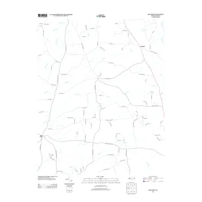
2013 Map of Silk Hope
USGS Topo · Published 2013About this map
Silk Hope anchors this rural Chatham County landscape, where agriculture and hydrology define the community's layout in the early twenty-first century. The terrain is a complex network of small waterways, with Lick Cr and Terrells Cr branching out from the Haw River corridor in the northeast. This 2013 survey illustrates a region largely shaped by its family farms and country roads, featuring established agricultural operations like Triple M Farms and the residential pocket of Mellow Marsh Farms. The road network, including historic routes like Lindley Mill Rd and Silk Hope Lindley Mill Rd, follows the natural contours of the land, connecting the central settlement to outliers like Mandale. Prominent geological features such as Kids Rdg and Ferguson Rd rise above the drainage basins of Dry Cr and Harlands Cr, providing clear evidence of the Piedmont's characteristic rolling topography and its influence on local development.
Find a feature on this map
99 named features on this map. Tap any name to fly to it.
Don’t see what you’re looking for? This feature index may not catch every label — zoom into the map to look around manually.
Map Details
Editions of this 2013 Silk Hope Map
This is the sole edition of this map. No revisions or reprints were ever made.
Other maps of this area

1953 · Raleigh
USGS Topo · 1:250,000

1954 · Raleigh
USGS Topo · 1:250,000

1968 · White Cross
USGS Topo · 1:24,000

1968 · Bynum
USGS Topo · 1:24,000

1969 · Siler City
USGS Topo · 1:24,000

1970 · Pittsboro
USGS Topo · 1:24,000

1970 · Siler City NE
USGS Topo · 1:24,000

1974 · Silk Hope
USGS Topo · 1:24,000

1974 · Crutchfield Crossroads
USGS Topo · 1:24,000
1977 · Saxapahaw
USGS Topo · 1:24,000