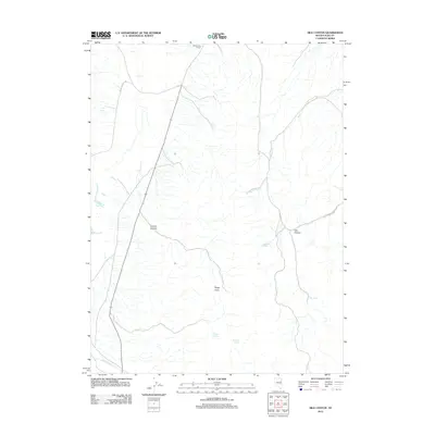
2012 Map of Silo Canyon
USGS Topo · Published 2012About this map
Butte Valley Ranch serves as a lone human marker in this remote stretch of northeast Nevada, where high-desert drainage patterns define the landscape. The terrain is characterized by significant natural depressions and rises, most notably Silo Canyon and Denton Canyon, which channel seasonal water toward the lower flats. The importance of water in this arid environment is evidenced by the density of named springs scattered throughout the hills, including Hill Spring, Picnic Spring, and Mustang Spring. These reliable water sources likely dictated the placement of ranching infrastructure and local routes like Butte Valley Rd. Creeks such as Phalen Cr and Taylor Canyon Cr cut through the topography, while Rocky Point provides a distinct geographical anchor for the surrounding rangeland.
Find a feature on this map
14 named features on this map. Tap any name to fly to it.
Don’t see what you’re looking for? This feature index may not catch every label — zoom into the map to look around manually.
Map Details
Editions of this 2012 Silo Canyon Map
This is the sole edition of this map. No revisions or reprints were ever made.
Other maps of this area

1955 · Elko
USGS Topo · 1:250,000

1958 · Elko
USGS Topo · 1:250,000

1962 · Elko
USGS Topo · 1:250,000

1965 · Elko
USGS Topo · 1:250,000

1984 · Currie Gardens
USGS Topo · 1:24,000
1984 · Mt. Taylor
USGS Topo · 1:24,000

1984 · Silo Canyon
USGS Topo · 1:24,000
1984 · McDermid Ranch
USGS Topo · 1:24,000

1984 · Delcer Buttes
USGS Topo · 1:24,000
1984 · Palomino Well
USGS Topo · 1:24,000